KANSAS CITY, MISSOURI, US — In the midst of a dissipating El Niño pattern World Weather, Inc has identified another short-term repeating weather pattern that recently has foreshadowed summer weather for both North America and western Asia. Both regions are likely to see high-pressure ridges aloft this summer and the pattern could bring some periods of dry and very warm to hot weather stressing crops and livestock in both areas.
Strong influential trends are present in world weather this year and there is enough agreement or overlap in the patterns that confidence is rising for a hotter summer in both the United States and in a part of Russia’s New Lands. The primary association will come from ENSO (El Niño/Southern Oscillation). There is a tendency for dry and warm to hot weather to evolve in the central United States, including the Great Plains, the western Corn and Soybean Belt and southeastern portions of Canada’s Prairies. The good news is that the pattern will not likely prevail too long without getting a little relief periodically. The bad news is that crop moisture stress is expected in unirrigated areas.
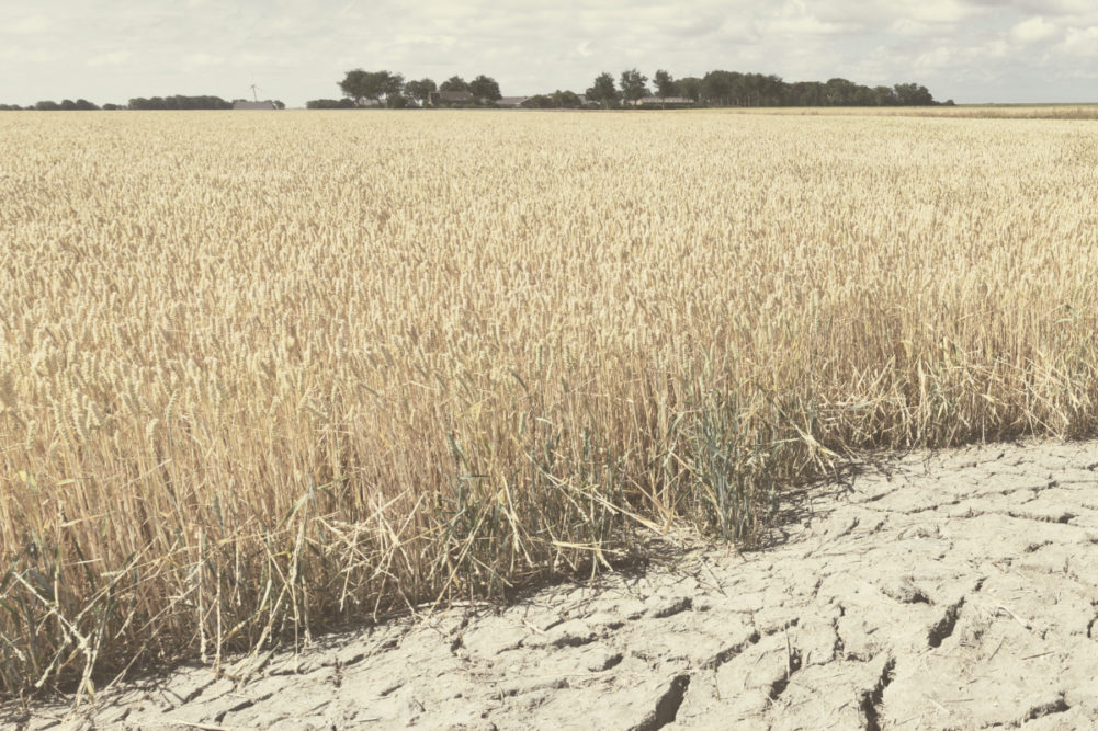
Last summer’s weather in the US Midwest included more than five months of below- to well-below normal rainfall. Crops managed to perform well in the environment because of no persistent hot weather. This spring and summer could be different with some distinctive periods of very warm to hot weather occurring while rainfall is minimal.
The most dominating part of the forecast will come from ENSO. This year’s El Niño event that was moderately strong in January was nearly dissipated in early April. The phenomenon should completely dissipate by the end of April, but a footprint of anomalous weather will remain for a few more weeks.
La Niña has been predicted by many weather forecasting firms. Some of the forecasts suggested La Niña would be possible by June while others suggest the change is more likely in July and August. World Weather, Inc. has learned that years in which a definitive change from El Niño to La Niña usually end up with drier- and warmer-than-usual summers in the central United States. There is also a strong signal for similar conditions coming from the lunar cycle that controls the upper air wind flow at 18,000 feet. That is where the jet stream is most influential upon our weather pattern and this year’s pattern suggests a more definitive battle with heat and dryness during the heart of summer.
Another weather pattern has been discovered that is embedded in the jet stream influence from the lunar cycle. The pattern has been repeating at roughly 45-day intervals with some slight drifting to 47 days at times. This shorter-term pattern has been associated with the larger North America storm systems in recent months and also has been involved with some of the cold surges that have occurred since the end of November. The pattern was impacting the Northern Hemisphere during the week of April 15. It was at that time that World Weather, Inc. spotted a notable high-pressure ridge aloft over North America and another over the western part of Russia.
These two ridges are not just random events, but often are found in association with years of transition from El Niño to La Niña. The pattern that brought back another large storm to eastern Canada’s Prairies recently was last seen in early March when a major winter storm impacted northern and eastern Saskatchewan and Manitoba. The new storm affecting crop areas in central North America during the week of April 15 resembles a storm from early March and another that occurred in early to mid-January. The first time this pattern appeared was in the Nov. 24-Dec. 5 period. The repeating pattern is one of the primary reasons supporting the periodic hot summer coming up.
Each time the stormy (45-day) weather pattern appeared in the past it was preceded by a strong ridge of high pressure and very warm temperatures and then followed by some very cool weather. This month’s storm was preceded by 80° and 90° heat in the US Plains with 70s in eastern Canada. These temperatures were well above normal, stressing livestock and winter crops. As this pattern gets perpetuated during the late spring and summer it will help to induce other bouts of heat and dryness that could threaten summer crop development and production.
Weather conditions in North America this spring, so far, have been better than those of last year, but there is concern that periodic bouts of hot weather this summer could induce some harm to crops. That warrants a close watch. Eastern and far western portions of North America should not be a part of the pattern.
In the meantime, some of the same weather influences threatening central North America weather during the coming late spring and summer also will evolve in the western CIS over Russia’s New lands, western Kazakhstan and some eastern Ukraine locations. Russia’s more recent high-pressure ridges of significance that occurred in a similar environment were noted in 2016, 2010 and 1988. In each of these years, heat and dryness impacted a portion of Russia, Kazakhstan and sometimes Ukraine. For US crop areas, the analog years to check into include 2006, 1988, 1970, 1952 and 1934.
It is too soon to determine intensity or breadth of the high-pressure ridge due this summer. However, 45-day weather cycle appearing in the week of April 15 should have much to say about the high-pressure ridges and their staying power during 2024.