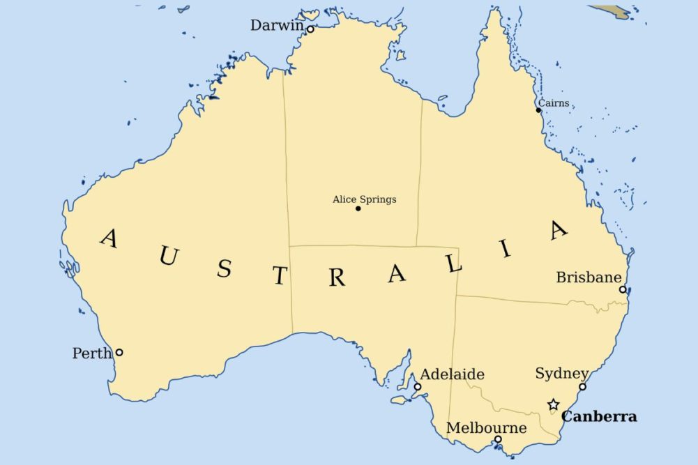
KANSAS CITY, MISSOURI, US — Media coverage of the growing flood situation in Australia has been as eye opening as the brush fires of just a few years ago when one of the worst droughts in recorded history was peaking.
It seems to make logical sense that extreme dryness would be followed by extremely wet conditions. That has been the way of life in Australia over the past 125 years and the cyclical weather trends are going to continue. This year’s wet bias has lived up to its full potential. The unfortunate part of the outlook is that the excessive rainfall is not over.
Much of this year’s wet bias was fueled by three waves of La Niña, but it was not operating alone. La Niña produces abundant to excessive rain in eastern parts of the nation the longer it persists and this event has prevailed since 2020. La Niña becomes more impactful the longer it prevails because as time moves along the ground becomes saturated. Then, when rain falls frequently and significantly, it can lead to flooding similar to that which has occurred so far this spring.
Flooding is occurring from Queensland to Victoria, but it has not been solely the impact of La Niña. Another phenomenon known as Indian Ocean Dipole has contributed greatly. Typically, spring and summer rainfall in a La Niña event favors greater-than-usual rainfall in eastern parts of the nation. Usually, the phenomenon has its biggest impact on Queensland and northeastern New South Wales during late spring and summer. That is when temperatures are very warm and when violent atmospheric updrafts occur to induce some intensive thunderstorm development. Strong thunderstorms produce heavy rain over short periods of time and with the ground already saturated and rivers running aggressively the potential for a worsening flood event is high.
Indian Ocean Dipole has two phases, a warm phase in which ocean temperatures are warmer than usual in the western Indian Ocean while cooler biased in the east. This positive, or warm phase of IOD, usually cheats Australia of some rain by keeping ocean water temperatures northwest of the country running cooler than usual. The cool water results in lower levels of atmospheric moisture moving from the eastern Indian Ocean into central Australia. This phase of IOD usually does not contribute greater-than-usual rainfall in the southeast of Australia, but rather less-than-usual rain.
The cool phase of IOD is just the opposite of that noted above. Warm ocean water pools over the eastern Indian Ocean southwest of Indonesia while cooler-biased water temperatures are prevalent in the western Indian Ocean and Arabian Sea. In this pattern, the warm water northwest of Australia feeds a continuously greater-than-usual amount of water vapor inland across Australia from northwest to southeast. Mid-latitude frontal systems and cool air masses that are moving from west to east across Australia draws the warm, moist, air from the Indian Ocean and bring it to southeastern Australia where the cool air masses will condense the moisture out as significant rain.
The combined impact of negative IOD and La Niña usually results in an abundance of rain and this spring has certainly shown that to be the case. The peak of wettest conditions occurred in early to mid-October with one storm system and rain event occurring after another. The ground became excessively wet and river and stream flows became excessively high resulting in flooding of low lying areas.
Australia’s wet weather pattern was showing signs of exhaustion in the last days of October and a break was getting underway from the overly active weather. Warming temperatures have been overspreading the nation in recent days and will soon help support convective outbreaks of significance, especially when the heat brings moisture out of the soil and lifts it high enough in the atmosphere to induce condensation and the development of rain. The summer environment should lead to a higher potential for severe thunderstorms and for the potential localized areas of torrential rainfall. Such conditions could bring more flooding to the nation’s wheat, barley and canola producing areas as well as to sorghum and cotton planting areas.
In past years when La Niña was beginning to weaken and abate from eastern Australia there has been a tendency for a more severe flood event to evolve. In past years when this was the case the damage done to cotton, sorghum and unharvested winter crops was significant.
Spring 2022 has been cooler and wetter than usual. That has winter grain and oilseed crop development behind the usual pace. Some harvesting of wheat, barley and canola has begun, but the bulk of harvesting is expected in November and December. That makes these next two months of critical importance for winter crops. The recent break from frequent rain will end soon and more rain will fall. This time, the greatest rainfall is likely to be in Queensland and northern New South Wales and there will be some potential for property and agricultural losses. Falling wheat, barley and canola quality could have a significant impact on the world supply of quality wheat.
More wheat damage in Australia would not go over well because of already low stocks for quality wheat. A notable decline in eastern Australia crop quality would translate into shorter world supply of the same and that could lead to more food inflation and supply shortages.
In the meantime, Argentina recently received some needed rain to improve its late maturing wheat and barley crop. The Argentina crop already has been reduced because of drought and neighboring areas of Brazil have suffered some grain quality decline because of a wet harvest. US hard red winter wheat production areas also are dealing with moisture shortages that could restrict production.
China and India, however, have seen a good environment for planting thus far this season while some of the crop in Russia may not emerge because of too much rain during the planting season.
Normally, Australia and Argentina represent the next insurgence of quality small grain into the marketplace, but the next few weeks will have much to say about the supply of quality grain and the price that will be paid for it. Western Australia production and quality are expected to be high, but not the eastern crop.


