Scientists continue to learn more about our oceans and atmosphere and how they interact with each other. Back in the infancy of this meteorologist’s career in the late 1970s, we had little to no clue just how much the ocean influences weather. Research over the decades has proven that the atmosphere’s engine is largely fueled by the sun and by the oceans. At first it was all about ENSO (El Niño Southern Oscillation – including El Niño and La Niña). But now it is becoming evident that other large anomalies in ocean temperatures can radically change weather.
The past few years have really driven this point home with huge regions of anomalous ocean temperature in various places in the world resulting in unusual weather. One such region was in the Gulf of Alaska in 2017 and 2018 when a super large region of cool ocean water, similar to that which occurred in 1988, evolved and suddenly Canada’s Prairies stopped seeing rainfall just like in the past. Drought that began in 2017 became quite severe in 2018 and lingered through early 2019, but that unusually cold ocean water anomaly in the Gulf of Alaska translated into a huge region of warmer ocean water in 2019 and it remains there today. Canada’s Prairies drought began diminishing in the summer of 2019 and it is predicted to fall away completely in 2020 because of the warm water bias.
Why has the water temperature had such an influence? It is all about water vapor. Anytime you heat up a body of water, no matter how slight the warming is, water vapor is released into the air. This is most evident in your kitchen when you start to boil water. As the pot of water warms, water vapor is released, but you cannot see it until the pot of water becomes exceptionally warm and you start to see steam coming off the water. Long before you can see the steam there is a steadily increasing amount of moisture reaching the air above the pot of water as the water warms. The air above the pot of water then warms as the water vapor is released into the atmosphere. Air that becomes warmer than its surrounding air will rise because it becomes less dense. As that air rises, it carries the water vapor up into the atmosphere along with the warming.
The rising air above the pot of water creates a region of low pressure because the air is moving away from the body of water, thereby reducing the weight of air pressing downward on the surface of the water. That is all that a low-pressure center is — just rising air. If you take the same principle out to the ocean and warm a super large area of ocean water, you release water vapor into the atmosphere and under ideal conditions you create a low-pressure center.
Today’s warm ocean water in the Gulf of Alaska has created a large region of low pressure with abundant moisture in the atmosphere. As storm systems move across the warm body of water, they tend to intensify by getting more lift by the rising air over the Gulf of Alaska and the added moisture rising in the atmosphere sets the stage for greater storminess once the warm, moist, air reaches a certain altitude when it meets colder air aloft. The dynamics in the atmosphere then become quite impressive as the warm, moist air meets the cooler air aloft and substantial rain falls downstream from where the storm center moved across the warmer-than-usual ocean body. Hence, the warm Gulf of Alaska this year has helped create more rain in Canada’s Prairies and brought drought conditions down in many areas. The longer the warm water remains in place, the higher the potential is for additional precipitation.
A few years ago, when the Gulf of Alaska was colder than usual, storm systems were not gaining moisture or lift from the ocean because the cool water was suppressing rising motions in the atmosphere. This in turn suppressed rainfall downstream across Canada’s Prairies, resulting in drought.
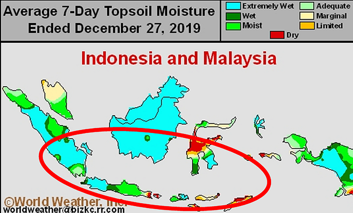
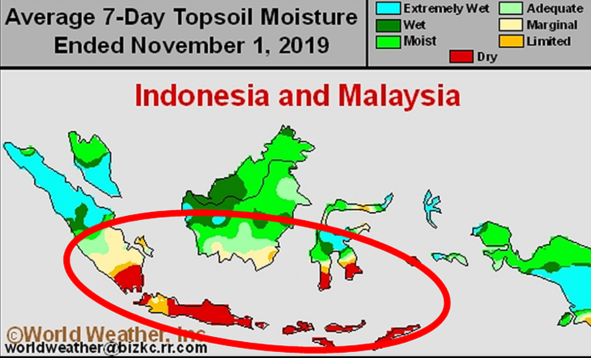
In 2019, western Indian Ocean water temperatures soared well above average while the water off the southwest coast of Sumatra, Indonesia, was colder than usual. The anomalies set records of extreme and some of the cold water southwest of Sumatra worked its way into Indonesia’s archipelago. The cold water from the eastern Indian Ocean into the Indonesian archipelago resulted in suppressed rainfall in Indonesia and northern Australia. The persistence of this feature resulted in prolonged dryness in southern Indonesia, even though there was no El Niño event. Scientists used to believe that the only way to get drought in Indonesia was from El Niño. This year proved that theory wrong.
Relief for Indonesia
The unusually warm ocean water in the western Indian Ocean and cold water in the east is called the positive phase of Indian Ocean Dipole (IOD). This year’s temperatures were so warm in the western Indian Ocean that record-setting rainfall occurred in eastern Africa and flooding was horrific in many areas. India’s monsoon was so enhanced with moisture from the warm ocean water that the seasonal rains had a hard time shutting down, and then there was Indonesia and northern Australia that suffered from serious dryness early in the year and were having a tough time getting rainfall even though there was no El Niño. The Indian Ocean Dipole phenomenon was breaking down in the fourth quarter of 2019. Ocean temperatures in the western Indian Ocean were cooling while warming was evolving from the eastern Indian Ocean into the Indonesian archipelago. As a result of this change, rain began falling in southern Indonesia. Rain during the 30-day period ending in late December was occurring more routinely due to the change in ocean temperature anomalies and a southward shift in the Inter-Tropical Convergence Zone, which we will cover in another article.
Australia’s drought might not have prevailed as extremely as it did in 2019 had it not been for the record positive IOD and a pool of significantly warm ocean water near the equator near the International Dateline. The cool water northwest of Australia and to the east of Sumatra, Indonesia, and the warm water near the International Dateline and in the western Indian Oceans were helping to create a massive region of higher-than-usual pressure over northern Australia and southern Indonesia. The high-pressure system prevailed for most of the Southern Hemisphere spring and early summer, preventing rain from developing in Australia’s key grain, oilseed and cotton areas in the south and east, making the 2017-18 drought turn into a third year and helping push the drought to record proportions in some eastern areas of Australia.
It will take little longer but as IOD breaks down and ocean water north of Australia warms up, the high-pressure system in Indonesia and northern Australia will break down more completely. Rain should begin falling in northern and eastern Australia as well as southern Indonesia over the next few weeks as these changes prevail. Drought may not completely end in Australia, but the prolonged rain-free period and excessive heat should soon abate.