This column could have been written in early September. That is how long it has been since there was a significant change in world weather. As they say…. “Is this the new normal?” There is nothing new about it. The same areas that were dry at the end of August and early September are still that way as of this writing in late October. The bigger question is when will it change? In the meantime, the only thing that can be said about “new normal” is to fasten your seatbelt because there is more wild weather coming. We just have to give the atmosphere a little nudge and the wheels of extreme will start anew.
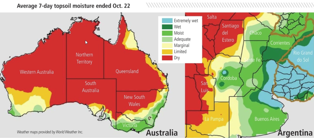
Eastern Australia is now in its 34th month of drought and for some areas it is a record drought. Queensland and New South Wales have been at the center of this dryness, but earlier this winter and spring (Southern Hemisphere) there was more dryness from one end of the south to the other slashing winter wheat, barley and canola yields. Scientists at Australia’s Bureau of Meteorology have blamed the winter/spring drought in central and southeastern parts of the nation on ocean temperatures across the Indian Ocean. Warm water in the west and cool water in the eastern Indian Ocean creates a positive phase of Indian Ocean Dipole (IOD), and that causes poor rainfall in central through southeastern Australia during the winter and spring seasons. The IOD index was near a record in early October and gradual changes are supposed to occur over the next eight weeks through November.
In reality, seasonal changes should bring some change to eastern Australia during November. Deepening low pressure in the northern part of the nation is in the process of turning the surface winds around. Instead of wind blowing from the heart of Australia into the eastern parts of the nation, the wind will soon blow from the ocean inland. When that takes place, rain will begin to fall. It will not, however, be drought busting rain, not with the IOD still in its strong positive phase.
It is too late to change winter crop production potential and the focus in Australia is now on sorghum and cotton, but the change toward wetter conditions cannot come quick enough to support dryland planting. Most likely, producers will be leery of planting a dryland crop with it being so dry today and the Australian Bureau of Meteorology touting dryness through December.
China also dry
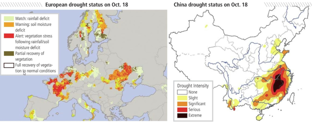
Australia is not the only place in the world with dryness issues. Eastern China remains drier biased as it has been since mid-September. Drought is quite extreme in the lower Yangtze River Basin where it is rare for serious droughts to occur. The impact in China has not been all that great, but the late double-cropped rice and sugarcane have been impacted. The bulk of summer grain and oilseed crops were maturing when dryness struck, and that should have minimized any negative impact. There is some concern over planting of wheat and rapeseed production areas, although a fair amount of that crop is irrigated.
China’s dry pattern is expected to last at least into early November, but there is some potential for relief later in the month when the tropical cyclone season ends and weather conditions in the East China Sea return to something closer to normal.
Dryness from the Balkan Countries through Ukraine and Russia’s Southern Region to Kazakhstan developed during the summer and has prevailed since then. There were a few weeks of scattered showers during late August and early September that offered some temporary relief from the driest conditions. Soil moisture improvements occurred for a little while in portions of Russia’s Southern Region and eastern Ukraine. Romania experienced a little relief for a brief period of time. However, moisture deficits are still present in most of these areas as of late October.
World Weather, Inc. believes, however, some change will occur in November, although it will come too late to improve winter wheat, barley, rye and rapeseed establishment in some areas. There was enough timely precipitation during the planting season that fair stands have evolved, but crop establishment could have been better. Poor emergence and establishment in some winter crop areas may lead to a higher risk of winterkill if extreme winter conditions evolve without adequate snow protection.
Western Argentina has been dry since its planting season finished in July. Some of the wheat crop has not developed very well and there is potential for some decline in yield. The most important production region in Argentina is Buenos Aires, and that province has experienced a more favorable weather pattern this spring, which will help to reduce some of the production losses if rainfall stays lacking in other areas for a few more weeks.
Argentina’s outlook for November is not much better than that of October, although some rain is expected to evolve in a timely enough manner to support a little improvement. Yields are still expected to be a little light in minor production areas to pull production down at least a little.
South Africa dryness is not unusual during the heart of winter (Southern Hemisphere) and early spring, but dryness has prevailed a little too long. Its winter wheat and canola were off to one their best starts in years, but dryness now is threatening production. Rain needs to fall during reproduction and time is quickly running out.
South Africa weather will improve in November, too, but it may be a little late for the best yields of winter crops and summer crop planting will have to occur aggressively as soon as significant rain falls to get crops planted during the optimal yielding season.
India too wet
India’s weather also has been unchanging, but instead of it being too dry it has been too wet. The monsoon refuses to abate. The southern half of India continues to receive frequent rain, and some of it has expanded recently back into central parts of the nation. Significant daily rainfall in Maharashtra and southern Madhya Pradesh in late October is unusual and it could raise a soybean quality issue for some areas if the weather does not change soon. The two-week outlook keeps the wet bias going, but World Weather, Inc. anticipates some change in November as well as other areas in the world. Some areas in India are quickly becoming too wet, raising the importance of a weather change soon.
Southeast Asia’s rainfall turned erratic and mostly lighter than usual during the middle of summer and many areas are still dealing with that environment today. Southern Sumatra, Java and the Lesser Sunda Islands have been drier than usual for many months and need rain to bring back a more favorable environment for rice, corn, sugarcane, rubber, tea, palm oil, cocoa and host of other crops. Changes have occurred recently in northern Sumatra, parts of Borneo and in portions of Sulawesi, but more rain is needed and it is not expected to come right away, but perhaps gradually later in November.
Not all areas have been stuck with dryness. Some rain has finally evolved in France, Spain and parts of the United Kingdom. Portions of Canada’s Prairies have trended wetter easing dryness, but creating some harvest issues, especially in Manitoba. Some of the Canadian wet weather also has reached into the north-central United States where drying is needed, but not likely for a while. West-central Africa coffee and cocoa areas are staying wetter biased for a longer than usual amount of time — like India.
Even though it looks like the world’s weather is on hold, nature is likely just resting after a few wild years and World Weather, Inc. guarantees more volatile weather in the next several months and years. So, enjoy the tranquility while you can.