ARLINGTON, VIRGINIA, US — The US Wheat Associates (USW) debuts new interactive map of the US wheat production and supply system as a visual planning tool for its overseas representatives and their customers.
“With six distinct wheat classes grown across many states and delivered by many different routes, the US wheat supply chain truly is driven by geography,” said Mike Spier, vice president of overseas operations for USW. “The map provides a geographical information system that our team of representatives can use to help the world’s wheat buyers literally see where the wheat they are buying is grown and how it can be transported to the export elevator.”
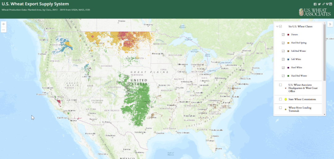
The “USW Wheat Export Supply System” map includes a selection tool that allows the viewer to identify, in any combination, US wheat production by class, wheat shuttle loading terminals, Class 1 US rail lines and spurs, river terminals, major rivers and export elevator locations.
“Assisting overseas customers is a very important service that helps add value to US wheat,” said Steve Mercer, vice president of communications for USW. “This map will be a unique and very useful addition to the trade service our representatives conduct all around the world.”
Using funds from the US Department of Agriculture’s (USDA) agricultural trade promotion program and in partnership with the Heartland GIS the digital map is now available on the USW website for use.
“Working with US Wheat Associates and its state wheat commissions, we used data from multiple sources, including satellite imagery, to identify wheat planted area between 2013 and 2019,” said Todd Tucky, owner and senior consultant of Heartland GIS. “I believe this is the most accurate representation ever developed of where individual wheat classes have been produced in the United States.”